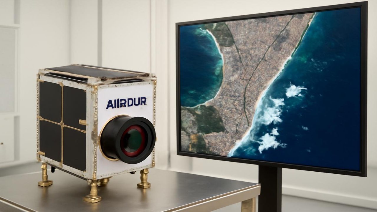
Airbus is preparing to launch a satellite that will capture Earth imagery at an unprecedented 20-centimetre resolution, setting a new world record for commercial space observation. This tiny spacecraft, barely the size of a household washing machine, represents a quantum leap in our ability to see and understand our planet from space.
The satellite currently sits in an Airbus clean room, surrounded by the hushed whisper of filtered air and the careful movements of engineers preparing it for launch. Once in orbit 600 to 700 kilometres above Earth, it will begin capturing images with detail so sharp that individual cars will show shape and orientation, rooftops will reveal solar panel tilts and ventilation units, and agricultural fields will display crop health with remarkable precision.
This breakthrough pushes commercial satellite imagery to the very edge of what regulations allow, threading the needle between technological capability and legal limits for publicly available Earth observation data.

How 20-Centimetre Resolution Changes Everything
The difference between current commercial satellite resolution and Airbus’s new capability might seem minimal on paper, but the real-world implications are transformative. Where older systems captured pixels covering 50 centimetres to a metre or more, this new satellite will detect details down to 20 centimetres per pixel.
At traditional resolutions, satellite imagery could identify roads, houses, and ships, but missed the subtle details that tell complete stories. The new system will capture the boundary between asphalt and curb, faint paths worn through grass, and small boats moored behind larger vessels.
This level of detail allows users to move beyond guessing to actually knowing what they’re observing. Instead of suspecting a crack in a runway, operators will see the actual tell-tale lines. Rather than simply counting shipping containers in a port, they’ll distinguish exactly how containers are stacked and arranged.

For agricultural monitoring, the enhanced resolution means detecting early signs of crop stress in the precise shape and density of field canopies, rather than making broad estimates about overall crop health.
Technical Specifications and Capabilities
The Airbus satellite represents a new generation of Earth observation technology, packing sophisticated optics and carefully tuned sensors into a remarkably compact package. This approach reflects the modern space industry’s shift from massive, bus-sized satellites to smaller, more efficient systems.
| Specification | Details |
|---|---|
| Resolution | 20 centimetres per pixel |
| Size | Approximately the size of a household washing machine |
| Orbital altitude | 600-700 kilometres above Earth |
| Regulatory status | Operates at the legal threshold for commercial imagery |
| Operational capability | Daily imaging for multiple years |
The satellite’s optical systems are engineered to maintain this exceptional resolution consistently, day after day, for years of operation. The signal-to-noise ratio and revisit time capabilities position it ahead of current competitors in the commercial Earth observation market.

The New Space Race: Resolution Over Size
The aerospace industry has fundamentally shifted from the traditional space race measured in tonnage and thrust. Today’s competition focuses on seeing more clearly, more often, with less mass and lower costs. Resolution has become the sharp tip of this technological spear.
While competitors have gradually approached the 25-centimetre barrier for commercial imagery, Airbus has pushed further, narrowing pixels and tightening focus in a package far smaller than previous generation satellites. This achievement represents years of engineering refinement in optics, sensors, and spacecraft design.
The 20-centimetre threshold is carefully engineered to comply with regulations limiting commercially available resolution. What classified military satellites might achieve beyond this threshold remains undisclosed, but the new Airbus system operates at the maximum resolution permitted for open market sales.

Real-World Applications and Impact
The enhanced resolution capabilities will transform multiple industries and applications. Urban planners will track infrastructure changes with unprecedented detail, monitoring everything from traffic patterns to building modifications in real-time.
Agricultural businesses will benefit from precise crop monitoring, detecting irrigation issues, pest problems, and growth patterns that were previously invisible at lower resolutions. Insurance companies will assess property damage with satellite imagery detailed enough to support claims processing.
Environmental monitoring will reach new levels of sophistication, tracking seasonal changes in rivers, following dawn shadow-lines across cities, and monitoring ecosystem health with texture-revealing detail. Scientists will observe how landscapes change over time, counting field lines like wrinkles on an ancient palm.

The maritime industry will gain improved vessel tracking and port management capabilities, while logistics companies will monitor supply chains and infrastructure with enhanced precision.
What Happens Next
The satellite awaits its launch window, with engineers having completed final preparations in the clean room environment. Once deployed, it will begin regular Earth observation operations, capturing the high-resolution imagery that will establish the new commercial standard.
The system is designed for multi-year operation, providing consistent daily coverage that will build comprehensive databases of Earth observation data. This sustained operation will enable time-series analysis showing how our planet changes over seasons and years.

Other aerospace companies will likely respond to this new benchmark, potentially driving further innovation in commercial Earth observation technology. However, regulatory constraints on commercially available resolution may limit how much further the industry can push these capabilities.
The success of this compact, high-resolution approach may influence future satellite design philosophy, demonstrating that smaller spacecraft can achieve superior performance compared to traditional large-scale systems.
Frequently Asked Questions
What makes 20-centimetre resolution better than current satellite imagery?
It reveals texture and fine details that 50-centimetre or metre-resolution imagery misses, allowing users to see car shapes, rooftop features, and agricultural details rather than just general outlines.

How big is the new Airbus satellite?
The satellite is approximately the size of a household washing machine, much smaller than traditional bus-sized Earth observation satellites.
Why is 20-centimetre resolution the limit for commercial satellites?
This represents the legal threshold for commercially available Earth observation data, carefully engineered to comply with regulations governing publicly accessible satellite imagery.
How often will the satellite capture images of the same location?
The satellite is designed for regular revisit capabilities, though specific timing details have not been disclosed in available information.

What industries will benefit most from this enhanced resolution?
Agriculture, urban planning, insurance, environmental monitoring, maritime operations, and logistics will all gain significant advantages from the improved detail level.
When will the satellite launch?
The satellite is currently in final preparations, but a specific launch date has not been confirmed in available information.


Leave a Comment